

Our region
WRW covers a very diverse region, including iconic National Parks and major city-regions.
Our region comprises the North West, the Midlands and the cross border catchments between Wales and England. Around 18 million people live here, in around 8 million properties and they need around 4.5 billion litres of public water supplies to be available each day. In addition to these public water supply needs, the region also has a significant number of other abstractions supporting a wide range of uses. The second largest water need is for the Canal and River Trust, requiring an average of 743 million litre per day. All other sectors, including as industry, power generation, and agriculture, together have a consumptive water need of around 334 million litres a day.
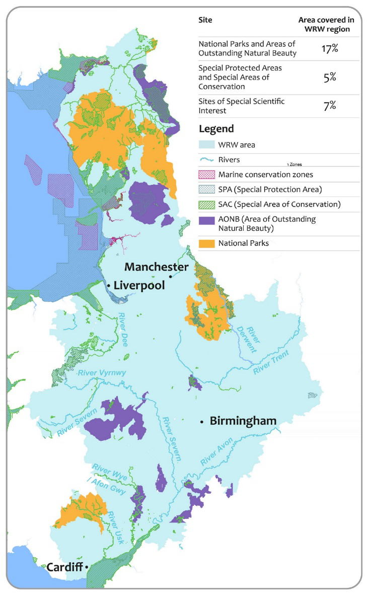
Water Resources West covers four of the eight largest city regions in the UK: Cardiff, Greater Manchester, Merseyside and West Midlands. It also includes iconic National Parks, such as the Lake District, Peak District and Brecon Beacons. Several of the UK’s major rivers such as the Severn, Dee, Trent and Wye, flow through the region. Major industry, agriculture, navigation, recreation and tourism all depend on these rivers and other waterbodies. All these focal points help demonstrate the scale and the diversity we must consider when planning our water resources.
Another area of diversity can be seen in the large-scale variability of the underlying hydrology. This includes meteorological, geological and topographical characteristics. The WRW region is generally more mountainous and on average, wetter than other parts of England; this contributes to its water resource availability. There are a large number of upland reservoirs in the region. However, there are also areas in the Midlands where average rainfall is lower and areas with a significant dependence on groundwater. This mix of different hydrological characteristics is reflected in our planning.

Boundary of the Water Resources West region covered by the regional plan.
Such diversity is also reflected in land use across the WRW region. For example, there are large areas of forestry, upland farms and pasture for livestock. But there are also areas of high value arable land and horticulture. When planning for the region’s water resilience, land use is an important consideration as it shapes the demand for water. It also influences water availability, so as the region has a mixture of land use types, its plans must cater for that variability.
Different areas of England and Wales experience different kinds of drought and usually at different times. Droughts in northern and western areas are typically more localised, more frequent and less severe than droughts in southern and eastern areas. Work by the UK Centre for Ecology & Hydrology (CEH) has mapped these areas and shown that the WRW region spans areas of the country with each of these characteristics, with a transition area in between.
Among these varied catchment areas within our region, the major rivers of the Severn, Dee, Trent and Wye are shared water sources that connect the diverse areas. All water companies within WRW have an interest in more than one of these rivers. Many other abstractors also depend on these shared resources. By making the best use of opportunities to share resources we can seek to improve our resilience, the environment and encourage growth. Connecting and sharing resources over diverse areas is likely to provide more resilience than could be provided solely within an area of similar characteristics.

Water Resources West’s regional characteristics, including the different drought zones
(Source: Tanguy et al., 2021.)
We want to ensure that there is enough water available in the future to satisfy everyone’s needs. Our region joins together areas with public supplies provided by four different water companies: United Utilities, Severn Trent, South Staffs, Dwr Cymru Welsh Water and Hafren Dyfrdwy. It also includes a significant part of the canal network and a wide range of other abstractors. These include agriculture, the chemicals sector, power generation, paper industries, food and drink producers,and other industries. We have developed an assessment of all these water needs across the region – learn more.