
Idle & Torn
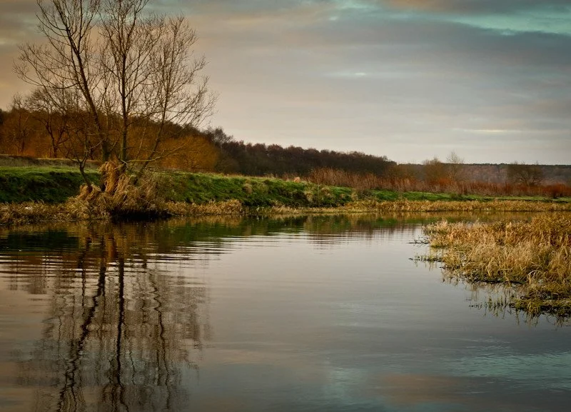
The Idle and Torne management catchment covers a broad and varied landscape, stretching across Nottinghamshire, North Lincolnshire and South Yorkshire. It is a region shaped by both its natural watercourses and its engineered landscape: much of the northern area lies at or below sea level and relies on extensive drainage to make the land farmable. Today, the catchment is predominantly arable, characterised by wide, open fields, historic towns and villages, and a rich industrial heritage that includes former coal mines, quarries and archaeological sites.
At the heart of this area are two operational catchments—the Idle River and the Isle of Axholme (which includes the River Torne). Together they contain numerous water bodies, from heavily modified drainage channels to river sections that feed into the tidal Trent. These watercourses support agriculture, local communities, and important habitats, including former quarry pits that have been designated as Sites of Special Scientific Interest (SSSIs). The catchment spans multiple districts and counties, making it a shared landscape where land managers, water companies and environmental partners all play a part in protecting water resources.
Several organisations abstract water from the catchment, with Severn Trent, Anglian Water and Yorkshire Water holding abstraction licences here. Groundwater abstraction is significant, with public water supply making up the majority of licensed use. Much of Severn Trent’s abstraction activity is in the Idle River Operational Catchment, where Severn Trent has already committed to reducing abstraction to help support environmental recovery. These actions reflect the wider ambition across the catchment: to balance the needs of people, agriculture and industry with the long‑term health of the Idle and Torne’s rivers, groundwater and wetlands.
For our Environmental Destination (ED) programme, we are focusing on a specific “area of interest” within the catchment, relevant to our abstractions. Our focus is those surface water bodies where we actively abstract water or where our groundwater abstraction impacts on flow to surface waterbodies. The Idle River Operational Catchment will be the focus area for Severn Trent’s WINEP investigation, we will also be linking up with Anglian Water and Yorkshire Water to share information, develop understanding and consider options.
We need your help!
Your involvement is crucial as we work together to better understand the Dove. We will be conducting a workshop on 21 May 2026 at Horsley Village Hall, Horsley, DE21 5BR. We hope you can attend and bring your local knowledge, practical experience, and on‑the‑ground perspective that we simply can’t capture through data alone. Together we hope we can build an accurate picture of the catchment, help identify viable water resource options, highlight potential opportunities to improve in-river ecology and shape partnership projects that genuinely reflect local priorities. Your input ensures that the plans we develop are realistic, collaborative, and capable of delivering real improvements for the water environment. Ultimately, by working closely with us now, you’ll be helping to secure healthier rivers, more resilient catchments, and better outcomes for the communities and sectors that depend on them.
Book your workshop place
What are our objectives and investigations?
Understand what river flow targets and changes to water abstraction may be needed to support a healthy water environment in the Idle & Torn.
Check how well the Environment Agency’s national modelling reflects local conditions. You can view their modelling in the Modelled Abstraction Reductions – National Framework for Water Resources 2025.
Compare the national modelling with improved local data to make sure we’re getting an accurate picture of the catchment and its needs.
Explore options to improve and protect river flows, including reducing our own abstractions where necessary. We’ll also look for opportunities to work with local partners and develop Nature‑Based Solutions (NBS) that strengthen the catchment’s resilience.
Use the evidence gathered to build confidence in any future abstraction changes, helping us prioritise actions and plan a realistic timeline for making improvements.
Feed into the development of our Water Resources Management Plan (WRMP), which outlines how we will meet long‑term challenges such as population growth, drought, environmental pressures and climate change, while ensuring a reliable water supply. The plan is being developed alongside the Water Resources West Regional Plan, which sets out how all abstractors in the region will work together to secure water supplies over the next 60 years. The first plan was published in June 2025 and is available here: Water Resources West Final Regional Plan — Water Resources West.
So who abstracts water and how much?
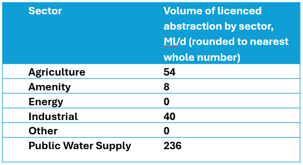
In the Idle River Operational catchment, Severn Trent has 12 groundwater abstraction licences for public water supply, and one abstraction licence for augmenting river flows in the river Ryton. The licence volume for these Severn Trent sources allows an average abstraction of 139Ml/d, Severn Trent have already committed to a reduction of nearly 20Ml/d from this volume by licence changes beginning in April 2030.
Anglian Water have abstraction licences allowing an average of 40Ml/d from the River Idle Operational Catchment, whereas Yorkshire Water’s average licenced abstraction of 83Ml/d is from the Isle of Axholme Operational Catchment.
The data in the table below is from the Environment Agency’s Modelled Abstraction Reductions - National Framework for Water Resources 2025, this incorrectly labels ‘Public Water Supply’ abstraction as ‘other’, to rectify this in the table below we have swapped the ‘other’ and ‘Public Water Supply’ volumes around. Please note the volumes below are total volumes for the whole Idle and Torne Catchment (total of both the Idle River and Isle of Axholme operational catchments) from both surface water and groundwater.
What have we done so far and what have we got planned for this investigation?
We are working to a deadline of 31 December 2026 to deliver the first phase of Environmental Destination investigations. By this date we will have developed abstraction reduction scenarios, compiled a high-level list of potential options which enable the proposed reductions or support the ecological needs of the catchment and we will deliver a narrative of how we have come to our decisions.
During 2025:
WRW water companies have been working together and with regulators to agree the scope and methods for these investigations.
We have been analysing data and previous investigations to develop an understanding of the catchments and understand current flow pressures and impacts on ecology.
During 2026:
We will be holding engagement sessions to talk to other abstractors, water users and stakeholders to develop our understanding of the catchment and pressures on water. We will be looking for opportunities to get involved in existing projects and work with you to develop new opportunities to improve water resources and low flow conditions in the catchment. Once confirmed the sessions will be listed here along with a booking form. In the meantime, you can register your interest by providing your contact details below.
We will be undertaking modelling work to enhance the understanding of the catchment, look forwards at the potential impacts under one or more climate change scenarios. Along with information collated from stakeholders we will assess the EAs national framework reduction numbers to identify what reductions may be needed in the future to public water supply abstractions.
We will begin to prioritise the actions that are needed and develop an approach through the WRMP and regional plan to address these.
Can’t join us at the workshop? We would still like to hear from you
Please complete the contact form below, letting us know things like: Do you want to partner with Nature Based Solutions? Are you already working on something in your area? Do you have any evidence of the catchment that you would like to share? Can you let us know the grid reference of the location you are referring to? What is your interest in the catchment? Do you have any thoughts you would like to share on our investigations?
If you would like to know a bit more about the data we are using for these investigations, below are the data sources we have used:
EA catchment data explorer: England | Catchment Data Explorer
Provides data used by EA in River Basin Management Plans
EA Environmental Destination Catchment Summaries: Catchment Summaries | Environmental Destination - Get involved! | Engage Environment Agency
Information to help understand the water resources challenge in local catchments
Modelled Abstraction Reductions - National Framework for Water Resources 2025: Modelled Abstraction Reductions - National Framework for Water Resources 2025
A spreadsheet showing a range of potential reductions to abstraction licence quantities which may be needed to meet environmental flow requirements